| Cerro Riso PatrónIntroduction How to get there Climbing historyWhere to find more information |
Update: last updated on 16/10/2015. Cerro Riso Patrón (ca. 2550m).
The Cerro Riso Patrón is located "en el culo del mundo", that would be around 49˚ 35' S 73˚ 40' W. The name remembers chilean geographer and mountain explorer Luis Riso Patrón (1869-1930) who was responsible for mapping much of the southern Andes. He was the director of the Oficina de Limites de Chile and was responsible for one of the teams that helped delineate the border between Chile and Argentina. In some places his last name is written altogether: Risopatrón, without space, but the cover of his book "Diccionario Geográfico de Chile" published in 1924 shows his last name separated in two words. In 1957 Eduardo Klenk, Andrés Pastewski and Jorge Peterek (AR) saw both summits of Cerro Riso Patrón from the summit of Cerro Don Bosco. Unaware that these peaks had already been christened (they were not noted in the maps they had), they named the south summit after Art Gilkey, an American climber that perished in K2, and the north summit after Stefan Bernadzikiewicz, a Polish climber that died on Nanda Devi East in 1939. It is not clear how high Cerro Riso Patrón is, nor is it clear how high its various faces are. When Casimiro Ferrari summitted Cerro Riso Patrón Central he noticed that Cerro Buracchio (2767m - GPS reading 2014) was clearly higher, so Riso Patron is likely between 2500 and 2600m. The Anoeker map shows it at 2507m. Using the program Google Earth and comparing photos to the nearby peaks and judging the vertical gain from the ocean, the east face of that central summit would have a vertical gain of around 900 meters and that the vertical gain of the west face of the south summit would be possibly close to 1100 meters. This of course are nothing but very rough estimates that might be completetly off. Many of the photos in this page are courtesy of the Groupe Militaire de Haute Montagne who in the 2000s did a reconnaissance fly-by in hopes of later making an attempt that for a number of reasons never materialized. Special thanks to Thomas Faucheur and Emmanuel Pellissier. There are two faces that seem particularly interesting, the east aspect of the Cumbre Central and the west face of the Cumbre Sur. Note that the Cumbre Sur is still unclimbed. Jerome Sulliva, who did the second ascent of the main summit points out that the rock quality isn't all that great, and suggests that it is best to look for ice and mixed climbing lines, which form usually anytime from September to November. Getting to the base is surely a big part of the challenge. It would be certainly possible to do so from the east, but it is a long long ways from Paso Marconi, over 70 km. From the west it involves taking the Navimag to Puerto Edén, then hiring a fishing boat to reach Fiordo Falcón. See climbing history for more details. Note that to secure authorization from Difrol you must have proof of rescue insurance (your card is not enough, you need a letter describing the coveraga and the contact person in case of emergency) and two satellite phones. Check with them months ahead of time so you can be prepared. The first photo on the menu bar to the right has the various approach routes marked on it. The main, central summit was first climbed by Casimiro Ferrari, Bruno Lombardini and Egidio Spreafico (IT) in August of 1988 via the southeast face. They reached the base from Fiordo Falcón. Also part of the team were Giuliani Maresi, Annibale Borghetti, Carlo Buzzi, Luigi Corti, and Luciano Spadaccini (IT). After the ascent they all headed east, exiting the Hielo Continental via Estancia Cristina, completing a west to east winter traverse of the Icecap. Before Ferrari's ascent there were a number of attempts, or intended attempts. In 1970 Pedro Skvarca (AR-SI) and partners hoped to attempt it but bad weather did not allow them to even reach the base. In late 1982 a French team led by Jean Marc-Boivin made an attempt from the west but they gave up when one (or two?) of the members got hurt. The team included Jean-Louis Etienne, Dominique Marchal, Denis Ducroz, Thierry Leroy and Bernard Prud'homme. Leroy replaced Patrick Berhault who at the very last minute pulled out of the expedition. About their objective they wrote that they "wanted to conquer one of the last unclimbed fortresses in the history of alpinism, Cerro Riso Patrón, a peak only accessible by the sea." They might well be right in their assessment. Riso Patrón is definitely a unique and appealing challenge. Not many unclimbed peaks like in the southern Andes. Around that time Carlos Comesaña and José Luis Fonrouge (AR) also traveled to the area to collect information for a later trip. When that trip did not materialize Comesaña passed on the information to Casimiro Ferrari. The letter that Comesaña sent to Ferrari in 1985 outlining everything he knew can be read here (in spanish - pdf format). Comesaña has been a tireless champion of this peak. His hope is to steer young alpinists to exploratory and remote objectives, hoping to revive a more traditional approach to alpinism. He has put together an impressive photo collection of unclimbed patagonian peaks here. For those coming from a different planet it seems pertinent to point out that Comesaña did the second ascent of Fitz Roy in 1965, via the Supercanaleta. Comesaña points out that Cerro Gaviota, the summit imediately north of Cerro Riso Patrón Central is also unclimbed. Fonrouge and Comesaña named it after the chilean boat they used to reach Fiordo Falcón from Puerto Natales. He also believes it is unreasonable to try to reach the west face of Cerro Riso Patrón Sur from the east, suggesting instead approaching from the west, via Fiordo Falcón. In 2009 Hervé Barmasse, Daniele Bernasconi and Giovanni Ongaro (IT) traversed the Ice Cap from east to west and took some great photos of Riso Patrón that show quite well a possible approach from the east. In 2014 Lise Billon, Martin Elias, Antoine Moineville and Jerome Sullivan approached the west face of Cumbre Sur from the west. They took the Navimag to Puerto Edén, then hired a fishing boat to take them to Fiordo Falcón. Here they established basecamp. From here they walked to a first lake, which they crossed with a raft, and then a second. In all they estimate that the base of the face can be reached in 12 hours from basecamp. Near the base of the wall Jerome fell in a crevasse and dislocated his shoulder so they had to call it quits before being able to do any actual climbing. A photo gallery of their adventure here. During that expedition they proposed baptizing the approach valley with the name Comesaña, and the bay where they landed with the name Fonrouge. In late September 2015 Lise Billon, Antoine Moineville and Jerome Sullivan returned, this time with Diego Simari. Over three days they climbed “Hasta las Webas”, a new route in the east face of Cerro Riso Patrón Central (1000m ED-, route line here). This was the second ascent of the peak. Originally they had hoped to attempt the west face of Cerro Riso Patrón Sur (a virgin summit), but the amount of icebergs in Fiordo Falcón did not allow them to reach the beach from where they had approach the previous year, so they were forced to change plans. Instead they headed to Riso Patrón Central, approaching from the west and north, across a valley, up to a rigdge, across a glacial plateau and a pass, to drop down to the base (2.5 days in all). They describe finding very good climbing conditions, with big sheets of ice covering most of the face. Most of the pitches were sparsely protected ice (to 5+), with a few mixed sections (to M5) and two very good rime pitches. They bivied twice in the face and descended to the north. A photo gallery of the expedition here.
Buy a copy of Silvia Metzeltin and Gino Buscaini's book: Patagonia: Terra Magica per Alpinisti e Viaggiatori (Dall'Oglio, Milano, 1987). The Italian version can be purchased through Amazon. It is an excellent book, well worth every penny. The Spanish version published by Ediciones Desnivel is of much lesser quality than the original and has many translation mistakes. The first issue of the Cuadernos Patagonicos, published by Tecpetrol (Techint) was dedicated to the various expeditions from the Ragni di Lecco to Patagonia and that includes information from Ferrari's ascent. This and all other editions of this publication can be found in the mountaineering archive we created together with Club Andino Bariloche and the Linguistics Department of the University of Innsbruck here. In 1983 Pierre Baudy wrote a book about the expedition led by Jean Marc Boivin. The book is called "Sur les traces de personne - Expédition Gauloise III Patagonie". It is available cheaply in Amazon and might have useful information.
|
Photos (click to enlarge) 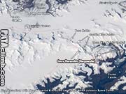
Cerro Riso Patrón - location overview 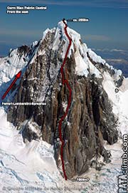
Cerro Riso Patrón from the east 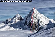
Cerro Riso Patrón from the east 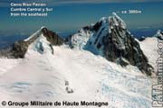
Cerro Riso Patrón from the southeast 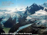
Cerro Riso Patrón from the south 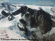
Cerro Riso Patrón from the west 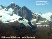
Cerro Riso Patrón from the west 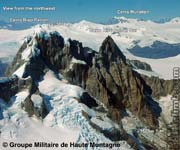
Cerro Riso Patrón from the northwest 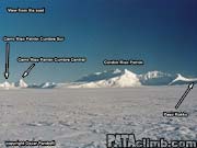
Cerro Riso Patrón from the east 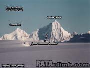
Cerro Riso Patrón from the east 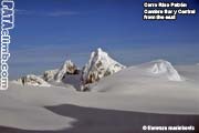 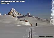
Cerro Riso Patrón from the east Cerro Riso Patrón from the east |
SITEMAP
If you find this web page useful, please consider making a donation
CLIMBING AREAS |
KNOWLEDGEDISCLAIMER COPYRIGHT CONTACT DONATE |
Climbing is dangerous, take responsibility, climb at your own risk. © 2010 Rolando Garibotti. All rights reserved.