| Cerro San LorenzoIntroduction How to get there Supplies What to bringWhen to visitRescueWhere to find more informationWeather forecastingClimbs and attemptsMain SummitSudafricana No FiestaNorafricanaAmericanaVariante Cafe CortadoNorth ridgeCalvo-de la CruzEl Faro (Pilar Sur)La MilagrosaNE face attemptsKastelic-Petrovcic Aguja AntipastoRomance ExplosionCumbre Buscaini (Sur)Buscaini-MetzeltinHaba-tar |
Update: last updated on 22/04/2019. Cerro San Lorenzo. 3706m.
Cerro San Lorenzo is a 3706-meter peak located in the border between Chile and Argentina in the vicinity of the 48th parallel, just north of the Perito Moreno National Park. The most interesting climbing on this peak is on the east and northeast face. This is where the “future” lies. The northwest and west side of the mountain, accessed from Chile are not interesting from a "climbing" perspective. This write up focuses only on the east and northeast side of the mountain, as an attempt to inspire folks to visit the area. For information on the normal route of Cerro San Lorenzo, climbing history of the peak or surrounding area, further information on the climbs mentioned here, etc, see the “Where to find much more information” section lower in this text. If you decide to visit the east side of San Lorenzo note that to the east and north there are a number of other peaks, Cerro Hermoso, Cerro Dos Picos, Cerro Penitentes, so even if you don’t climb San Lorenzo you can easily do a number of other climbs and have a great trip.
The east and northeast face is best accessed from the south via the Perito Moreno National Park, from where you can also reach the north face. You can also reach the area from the north, from Lago Posadas and the Río Oro but for a number of years there were issues with one of the land owners, who demanded large sums of money to pass through his property. Recently apparently he allows free passage. The north face and the east face of the Hombro Norte can be reached by crossing illegally from Chile, from Cochrane. Unless you have your own car, to get to the Perito Moreno National Park, you will need to get to Gobernador Gregores via public transport (there are buses from El Calafate and Río Gallegos) and there you will have to hire a car or truck to take you in the remaining 200 kilometers to the Park. Ask Virginia and Abel at hotel Cañadon Leon (+ 54 2962 491082 - Spanish only). They have provided transport to many climbers in the past. The approximate cost for drop-off and pick-up is U$900 (over 800km of driving in all). There are two estancias in the area that work work with tourists, Estancia Menelik and Estancia La Oriental, but services at both are expensive. Although you will only walk a few kilometers inside the National Park (the peak is in a Provincial Reserve) be sure to get a permit and tell them what you are doing. I would suggest contacting the park ahead of time to let them know you are coming. Ask your ride or drive past Puesto Rincón, to the very end of the road. From here you will continue on foot, hiking three hours to reach Puesto San Lorenzo, which is a good place to establish basecamp. The land north of the National Park, including Puesto San Lorenzo used to be private, but it was purchased and subsequently donated by Doug and Kris Tompkins to the National Park. You will have to carry all your loads to basecamp on your own back because pack-horses are not permited within the park. If you plan on leaving your supplies at the end of the road, ferrying them to Puesto San Lorenzo slowly and as needed, take plastic barrells or similar, something that can be locked and where food can be safe from rodents. Alternatively, you can leave your supplies at Puesto Rincón, but this will mean that each time you will walk an extra 45'. Note than it is not possible to approach the south side of the peak from the south. The area to the south of the peak is rated as "zona intangible" by the National Parks Administration, meaning that for conservation reasons it is closed to humans. To access Pilar Sur you have to head north to Puesto San Lorenzo, then west onto the glacier, then back south. There is a big supermarket in Gobernador Gregores where you will find everything you need. You can also find white gas (solvente) in Gregores. Bring all specialty mountains food: bars, gels, freeze dries from home and buy propane canisters and other unusual items in El Calafate or Río Gallegos. Because the area is fairly remote a satellite phone could be a useful tool. If you have one then you can ask a friend or family member to send you regular weather reports. Note that if you plan to climb a route in the east face and descend to the west, to Chile, you will need your passport and some cash (in case), plus a good map and a GPS to find the descent down the De Agostini route in a storm. For any of the climbs in this face you need cold weather, as cold as possible, so the earlier the better. Consider going between October and December. Note that in September the road can at times be impassable (mud, snow, water). January and February are too warm. Mid-March and later might also provide good conditions. There is no rescue team anywhere close. If you have an accident, you are on your own. Your only option is self-rescue. There is no help to be had, you and your partners is it. Take a well furbished first aid kit and climb with a big enough team (at least three people - preferably more) to have the man-power to carry out self-rescue. Every member of them team should be capable. This is no place for siesta or a picnic. If you get hurt, you are fucked. Even body recoveries are virtually impossible in that area. Make sure you plan ahead of time for a potential emergency - read the risk managment doc we put together: here (in spanish here). Also read the fine print in your rescue insurance policy carefully, so you know what is covered and what is not. Any intervention will cost upwards of U$20,000, so make sure your policy covers that amount or more. Climbing routes. The main purpose of this write up is to showcase all the virgin terrain that remains, including the impressive tower to the far south of the east face, the Pilar Sur, reknowned for bad quality rock (very fractured granite). Regarding the east face one important note, the face is crowned in many places by what looks like a serac or large cornice. It is unclear if these cornices or seracs are active or not. They appear not to be but that is a judgment call that you will have to make. In late 2009 English Mick Fowler and Es Tresidder visited the area. After the visit Es wrote me an email saying the following: “The main problem though was that we failed to find an objectively safe-enough route on the whole east face, despite lots of looking! Looking back we reckon there is only one line in the whole 4km long wall that is not either threatened by very active seracs, or terminates in a 100m+ high, overhanging cornice! That line would be very hard, too hard for us we decided, but it does look very good, like a harder version of the Moonflower buttress! Cumbre Principal East ridge. Sudafricana. A 1500-meter long classic mountaineering route climbed by South Africans Hans Petter Bokker, Russel Dodding, Paul Fatti and Erwin Muller in 1986. It has been repeated a number of times, including one 10-hour ascent by German climbers Hans Holzmayer and Sebastian Thaller in 1995. Southeast face. No Fiesta. In November 2015, Dejan Koren, Rok Kurinčič and Boštjan Mikuž (SI). climbed a line to the left of the east ridge, a section of the east face that is oriented to the southeast. They started from basecamp at midday and reached the base by 5PM. They started climbing at 7PM, following snow-slopes to 70°, unroped. By midnight they had covered 800m and had reached the first icefall that connects the lower and middle part of the face. Here they roped up, climbing mixed terrain to the first serac, traversing left for five pitches, across very hard ice, to find a passage between second and third serac. By dawn they reached the base of the third serac. Despite a windless weather forecast, a southeasterly wind picked up around midnight, becoming quite strong after sunrise. The wind prevented them from stopping to melt water so upon reaching the Sudafricana and the east ridge, having climbed 1600 vertical meters, and at an altitude of 3450m, they decided to call it good without continuing on to the summit. It was 3PM and they had climbed for 18 hours to that point. To descend, they rappeled the northeast face, which was protected from the wind, making around 40 rappels (1000m). They reached basecamp at dawn on 22nd, after being on the go for 40hs. They christened their route "No Fiesta" (ED+ 1600m). Northeast face. Nordafricana. Climbed by Catalans Oriol Baro and Jordi Corminas in 2008, in 30 hours round trip. They climbed to the base of the summit mushroom where they joined the Sudafricana and from where they retreated. This is the first line to tackle the NE face, one of the steeper and more interesting faces that San Lorenzo’s offers. French Jean Annequin and Simon Destombes had made an attempt in 1998, climbing 1000 meters before retreating. North face. Americana. Climbed by Americans John Hauf, Timothy Rawson and Tom Walter in 1987, to the base of the summit pyramid from where they retreated (see AAJ 1988 pp. 173-174). In late 2014 JP Auclair and Andreas Fransson died in this couloir when they were swept by an avalanche. They were climbing up with skis on their backs, in hopes of skiing it. The avalanche started above, the result fo warm temperatures. If you plan on climbing this line, only do so when it is cold, and even then go very very early in the day. North face. Variante Cafe Cortado. Climbed by Italians Herve Barmasse, Matteo Bernasconi, Giovanni Ongaro and Swiss Lorenzo Lanfranchi in 2006. Follows the American line for the first 1000 meters and where the Americans climbed up and right continues straight. In that section lies the crux of the climb: a short but difficult S-shaped goullote that brought them to the summit mushroom. They reached the top in ten hours of climbing. Filo Norte Calvo-de la Cruz. In the north face of the ridge that heads north from the North summit, above the Glaciar De Agostini (approached from the Campamento de Agostini), there is at least one climb, completed by Argentines Ramiro Calvo and Nicolas de la Cruz in the early 2000s. It climbs an easy snow gully (60˚) to then get into trickier mixed terrain on farily bad quality rock. El Faro (Pilar Sur) Pilar Sur is the big tower at the south end of the east face. It's north face has over 1000m of vertical gain (likely around 1200m). The rock is far from good. Note the amount of rockfall debris at the base after warm periods. La Milagrosa. In October of 2018, Martín Elias (ES), Francois Poncet and Jerome Sullivan (FR) did the first ascent of the Pilar Sur, which they christened El Faro. Their route tackles the left side of the east face to hop on to the south face. The crux section is a chimney with fairly poor rock, which involves two pitches with difficulties to A3. They called their route “La Milagrosa”, 1200m M7 A3 6a. They carried doubles to #3, one #4, Stoppers, 8 pitons, 8 ice-screws. In 2013 Luciano Fiorenza, Pablo Pontoriero and others made an attempt on the northeast face, climbing eight pitches and retreating once they realize that the rock did not improve higher up as expected. In early 2016 Felipe Guarderas, Nicolás Navarrete and Roberto Morales (Ecuador) also made an attempt on the same face, retreating after 250m due to rockfall. In November of 2015, Domen Petrovčič and Domen Kastelic (SI) climbed the couloir between Pilar Sur and Cumbre Sur (from the north east) retreating upon reaching the col, without continuing on to either summit. The main difficulties of this couloir are at the start and finish, the middle section being somewhat easier. It took them 13 hours to climb, encountering difficulties to 90˚ and some mixed. They descended to the south, dropping into the glacial tongue of the Buscaini-Metzeltin route. Earlier Petrovčič and Kastelic had climbed a new line in Cerro Hermoso's southeast face. Aguja Antipasto Romance Explosion. In November of 2014, Colin Haley and Rob Smith climbed the small tower to the east of the Pilar Sur, which they christened Aguja Antipasto, as a reference to being merely an appetizer in comparison to the main course just behind. They climbed 14 pitches with difficulties to M5 6a+ and a few moves of A0. They descended the route in 12 rappels. They named their route “Romance Explosion”. The ascent required 22 hours round-trip from a bivy in the glacier below. The poor rock quality requires slow climbing. More info here. Cumbre Buscaini (Sur). Buscaini-Metzeltin. In 1986 Gino Buscaini and Silvia Metzeltin climbed the south face and west arete. The encountered multiple seracs, some of which they circumvented, others they climbed up and over. In all they covered 1700m with difficulties to 80˚. They bivied once during the ascent and retraced their steps to descend. Haba-tar. In early 2016, Felipe Guarderas, Nicolás Navarrete and Roberto Morales (Ecuador) made an attempt on Pilar Sur, retreating after four pitches due to rockfall. During that attempt Guarderas was hit by ice and headed to basecamp. Navarrete and Morales countoured the mountain via its south side and climbed a glacial tongue from the southwest, leading to a traverse below an arete, some tricky glacier travel and a steep ice slope to reach Cumbre Buscaini (to 75˚). They descended the line of ascent, downclimbing all but one section which they rappelled. They named their route Haba-Tar (800m 75˚).
There is an excellent little guidebook to the San Lorenzo area written by Silvia Metzeltin Buscaini. It is in Spanish and can be purchased here. Also you might want to buy a copy of Silvia Metzeltin and Gino Buscaini's book: Patagonia: Terra Magica per Alpinisti e Viaggiatori (Dall'Oglio, Milano, 1987). The Italian version can be purchased through Amazon. It is an excellent book, well worth every penny. The Spanish version published by Ediciones Desnivel is of much lesser quality than the original and has many translation mistakes. The ninth issue of the Cuadernos Patagonicos, published by Tecpetrol (Techint) was dedicated to Cerro San Lorenzo. This and all other editions of this publication can be found in the mountaineering archive we created together with Club Andino Bariloche and the Linguistics Department of the University of Innsbruck here. It is somewhat outdated, but it is still a good source of information.
|
Photos (click to enlarge) 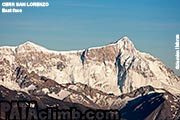
Cerro San Lorenzo - East face 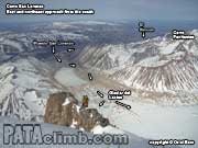
Cerro San Lorenzo - Río Lacteo 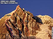
Cerro San Lorenzo - E & NE face 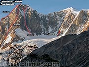
Cerro San Lorenzo - north face 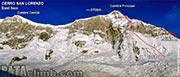
Cerro San Lorenzo - east face 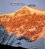
Cumbre Central - east face 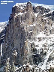
Cumbre Central - east face 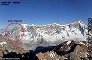
Cerro San Lorenzo - east face 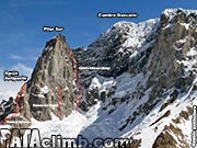
Aguja Antipasto, El Faro (Pilar Sur) & 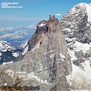
El Faro (Pilar Sur) 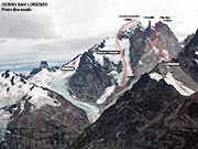
Cerro San Lorenzo - south face 
El Faro, La Milagrosa, topo 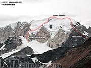
Cerro San Lorenzo - southwest face |
SITEMAP
If you find this web page useful, please consider making a donation
CLIMBING AREAS |
KNOWLEDGEDISCLAIMER COPYRIGHT CONTACT DONATE |
Climbing is dangerous, take responsibility, climb at your own risk. © 2010 Rolando Garibotti. All rights reserved.