Grand Teton National Park, Wyoming.
Grand Traverse
Description. This is a north to south traverse of ten of the Grand Teton’s range most important summits. The starting elevation in the valley floor is 6,700 feet. The summit elevations in order are: Teewinot 12,324 feet; Mount Owen 12,928 feet; the Grand Teton 13,770 feet; Middle Teton 12,804 feet; South Teton 12,514 feet; Cloudveil Dome 12,026 feet; Nez Perce 11,901 feet.
The cumulative elevation gain is about 12,000 feet with difficulties up to 5.8, the length about 17.9 miles, with an estimated time required to complete an ascent between one to three days.
Below is a rough description, giving particular attention to the sections that are not discussed in Renny Jackson’s excellent guidebook. Use the guidebook to fill in all other information about other routes.
History. See bottom of the page. |
Photos (click to enlarge)
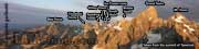
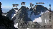
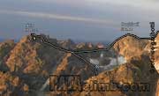
Overview |
Teewinot.
Climb Teewinot's via the east face route (4th class). If you plan to do the route in one day try to reach Teewinot’s summit right at dawn.
Teewinot to Mount Owen.
From the top of Teewinot go back down the way you came up for about 200 vertical feet and then traverse to a saddle just south of the summit. Go up slightly to a second saddle to the south from which you can walk south and west towards Peak 11,840.
There are three options to pass Peak 11,840. If there is little snow you walk around it’s north side. While this is the fastest option beware that it involves much scrambling across very steep “dirt”, which is no fun and fairly dangerous. A second alternative involves down climbing a fairly loose chimney on the NW face. The safest option is to rappel down the SW face of Peak 11,840. To do so, go to the very top of it, and then drop southwest into a gully for about 100 feet to a first rap station. Three 100-foot long raps allow you to reach the ground. Beware that with a 200-foot rope you barely make it on the last rap, so watch the ends. Wrap around NW to get back to the ridge.
The ridge between Peak 11,840 and the East Prong is climbed mostly on the north side. To reach the Koven col from the summit of the East Prong you need to downclimb about 60 feet of 5.4 down the NW side or make two short raps. |
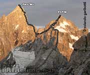
Teewinot to Grand Teton 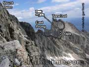
Teewinot to Mt. Owen 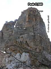
Peak 11,840 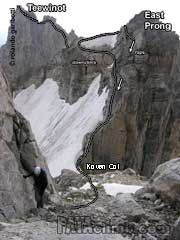
Teewinot to Mt. Owen
Mt. Owen |
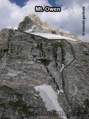
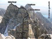
Mount Owen to Gunsight.
Mount Owen is climbed via the Koven route. From the top reverse your steps to easy ground just south of the summit pyramid. Drop down to the west via the first notch south of the summit. Rap or downclimb down a loose gully and after 200 feet head SW (skiers left) until a rock step stops you. Here go west (slight skiers right) 150 feet and drop into a large chimney/gully heading SW (skiers left again). At the end of it down climbing a few moves (5.4) or make a 15-foot rap. Drop a further 150 feet across easy ground, then traverse almost horizontally to skiers left, heading south, until you reach a faint ledge that leads you right above the gully leading to the Gunsight notch. As the faint ledge disappears you will be forced to climb a few moves until you find yourself 25 feet above the Gunsight. You can down climb this 25 feet, but it involves bad rock (5.6) so best to make a short rap.
|
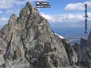
Mt. Owen - South face |
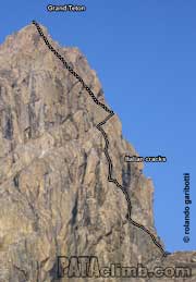
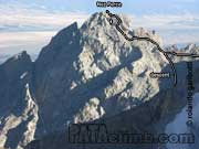
Gunsight to Lower Saddle.
Out of the Gunsight climb up and right 60 feet, then up and left 50 feet to a slanting ledge going down to the east. Head 100 feet down the ledge and then climb straight up. This is the best pitch of the Traverse, steep knoby 5.7. The following pitch is also very good, involving steep 5.6 on a wall facing east, with many knobs too. After those two pitches you should be able to put the rope away until the north ridge proper. The Italian cracks (5.8) are the fastest and most enjoyable option up the north ridge. From the summit of the Grand Teton the Owen route is the fastest way down (two 100 foot raps and much downclimbing).
|
Grand Teton |
Lower Saddle to South Teton.
Nothing special about this section, easy scrambling up the Middle Teton’s North Ridge, with a few 5th class moves mixed in, followed by a long descent down the SW couloir and an easy but tiring ascent up the South Teton.
South Teton to Cloudveil Dome.
Descend the east ridge (4th class) of South Teton and climb a steep crack up the left side of the west face of Icecream Cone (5.7). Descend Icecream Cone via its east face (3rd class) and climb over or cross under the north side of an unnamed “blob” to reach the west ridge of Gilkey Tower (4th class) then descend its east ridge toward Spalding Peak which is climbed via its west ridge (4th class) and descended via its east ridge (3rd class). Walk up the west ridge of Cloudveil Dome. For this entire section it is always best to stay right on the ridgeline. |
South Teteon to Spalding Tower
Ice Cream cone to Gilkey Tower |
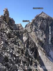
Cloudveil Dome to Nez Perce.
Descend Cloudveil's east ridge (4th class) to reach a col at it’s base. Here find a faint ledge on the north side of the ridge, and well below it, that allows you to traverse across to Nez Perce, which is climbed via the normal route.
|
Cloudveil Dome
Nez Perce
Cloudveil dome to Nez Perce |
Descent.
Descend Nez Perce via the same route returning to Garnet Canyon and the Lupine Meadows trailhead.
Pro. Alpine rack, plus a 60m rope (mandatory for the raps down the Grand). A single 9.1mm rope should help save weight. Depending on the amount of snow ice axe and crampons can be needed. Rock shoes are somewhat optional. A good approach shoe might be the best option..
Water. You can refill water on Mount Owen and in the Lower Saddle, sometimes also in the Middle Teton’s SW couloir.
Season. Late July to early September. Mid August usually provides the best conditions.
Achtung. If you plan to spend the night beware that a permit is required for overnight camping. This you can get at the Ranger Station in Jenny Lake.
HISTORY.
First ascent. Allen Steck, Dick Long, and John Evans climbed it from south to north in 1963. It took them 21 hours. Later the north to south traverse became the preferred route.
First winter ascent. Renny Jackson, Hans Johnstone, Stephen Koch and Mark Newcomb, climbed it in 2004.
Fastest known times.
Male . The first recorded FKT was set by Alex Lowe in 1988, with a time of 8:15. In 2000, Rolando Garibotti completed it in 6:49, and in 2016, Nick Elson established the current FKT at 6:30:49.
Mixed gender team. In 2000, Kim Csizmazia completed the route in 12:26 hs., climbing free-solo with Garibotti .
Female. In 2006, Julia Niles climbed it in 16 hs.
Bibliography.
- A Climber's Guide to the Teton Range, 3d ed., by Leigh N. Ortenburger and Renny Jackson.
- Fifty Favorite Climbs, by Mark Kroese, The Mountaineers, 2000 (see Alex Lowe chapter). |
|
Please Do Not Reprint This Article.
This article is copyrighted. Please do not reprint this article in whole or part, in any form, without obtaining written permission.
Feedback.
if you find any mistakes or if you have additional information, please go to the contact page and let us know. |
|
|