| Chaltén massif Introduction General Info Climbing there Weather forecasting
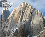
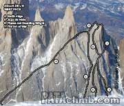
Peaks Fitz Roy Group
Torre Group
Cordón Adela
Piergiorgio & Pollone Group
|
|

SITEMAP
If you find this web page useful, please consider making a donation
CLIMBING AREAS |
KNOWLEDGEDISCLAIMER COPYRIGHT CONTACT DONATE |
Climbing is dangerous, take responsibility, climb at your own risk. © 2010 Rolando Garibotti. All rights reserved.